Introduction
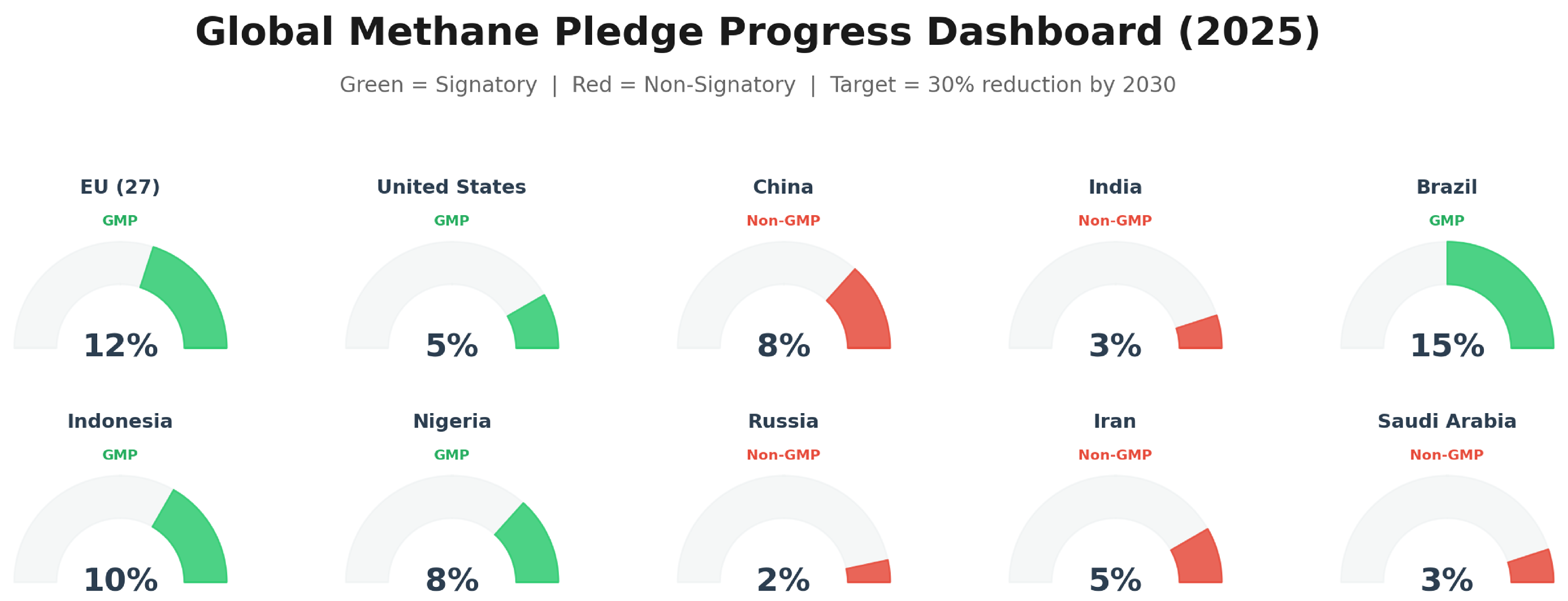
Methane is the climate system's most powerful near-term lever. Roughly 80 times more potent than carbon dioxide over a 20-year period but resident in the atmosphere for only about a decade, it is the greenhouse gas whose reduction can most rapidly slow global warming -- while delivering side benefits ranging from reduced air pollution to stronger crop yields [1]. That arithmetic underpins the Global Methane Pledge (GMP), launched at COP26 in 2021, under which more than 150 countries have committed to reducing collective methane emissions by at least 30% from 2020 levels by 2030 [2][3].
The pledge, however, arrives against a sobering trendline: atmospheric methane concentrations have climbed to record highs, as the UN Environment Programme's Emissions Gap Report 2023 highlighted [3]. The distance between those two facts -- bold commitments on one side, rising concentrations on the other -- is what might be called the enforcement gap. Methane's dispersed sources, irregular emission patterns, and frequent location in remote or hard-to-reach terrain have historically made it one of the hardest greenhouse gases to measure, attribute, and therefore regulate [3].
Into that gap has moved a rapid convergence of technologies: an expanding constellation of methane-sensing satellites, machine learning models capable of extracting faint plume signatures from noisy imagery, and early policy frameworks willing to treat orbital data as regulatory evidence [2][3]. The question confronting policymakers and scientists alike is no longer whether satellites and AI can detect methane emissions at scale -- increasingly, they demonstrably can -- but whether that transparency can be converted into enforceable accountability in time to matter for 2030.
 Mapping global methane emissions from space with deep learning
The Enforcement Gap: Why Pledges Have Outpaced Progress
A Voluntary Pledge in Need of Verification
The Global Methane Pledge is, by design, a political commitment rather than a binding treaty. Transparency in methane reporting has been described as one of its cornerstones [4], but until recently, verification relied heavily on self-reported national inventories built from generic emission factors rather than actual measurements. Industry initiatives have moved in parallel: member companies of the Oil and Gas Climate Initiative announced in March 2022 an ambition of zero methane emissions from upstream operations by 2030 [4], and the UN-brokered OGMP 2.0 framework now counts a growing roster of companies disclosing measurement-based data [5]. Still, self-reporting is not enforcement. As the GMP's own annual reporting acknowledges, closing the emissions gap requires actionable, measurement-based data to focus mitigation efforts and track progress over time [5].
Why Traditional Monitoring Falls Short
Before satellites became central, methane detection depended mostly on ground-based tools -- from handheld infrared cameras to fixed sensors and aerial surveys. These methods remain in use, but they struggle at scale. Remote landfills, offshore oil rigs, and deep mines can go unmonitored for extended periods, allowing methane to escape unnoticed; many emissions occur as fugitive leaks whose cumulative product loss hits operators' bottom lines even as they evade detection [6]. The economic irony is well established: in the fossil fuel sector, captured methane has commercial value, making abatement both technically feasible and economically favorable [2]. Methane reduction is often called the "low-hanging fruit" of climate mitigation -- but as one industry analysis put it, tracking that fruit is not as simple as it sounds [6].
A New Generation of Eyes in the Sky
The observational landscape now spans two complementary tiers. Large publicly funded satellites, such as the European Space Agency's Sentinel series, provide global coverage at coarser resolution, while commercial high-resolution constellations -- pioneered by GHGSat and joined by MethaneSAT and Carbon Mapper -- can pinpoint the individual facilities responsible for leaks rather than merely flagging regional hotspots [4]. This distinction matters because the most cost-effective mitigation strategies target localized point sources, emissions from spatial footprints of just a few tens of meters, across the waste, agriculture, and energy sectors [7].
What has changed most in the past three years is not just the hardware but the institutional appetite for its output. The U.S. Environmental Protection Agency has established a Methane Super-Emitter Program that leverages third-party satellite observations for regulatory enforcement [2]. The European Union has adopted legislation requiring monitoring, reporting, and verification (MRV) of methane across oil, gas, and coal operations -- explicitly including imports -- and its Copernicus monitoring mission is slated to deliver unprecedented operational capacity for anthropogenic emission verification starting in 2027 [2][3]. Orbital data is thus migrating from scientific curiosity toward evidentiary infrastructure.
Machine Learning: From Noise to Notification
MARS: The UN's AI-Assisted Alert System
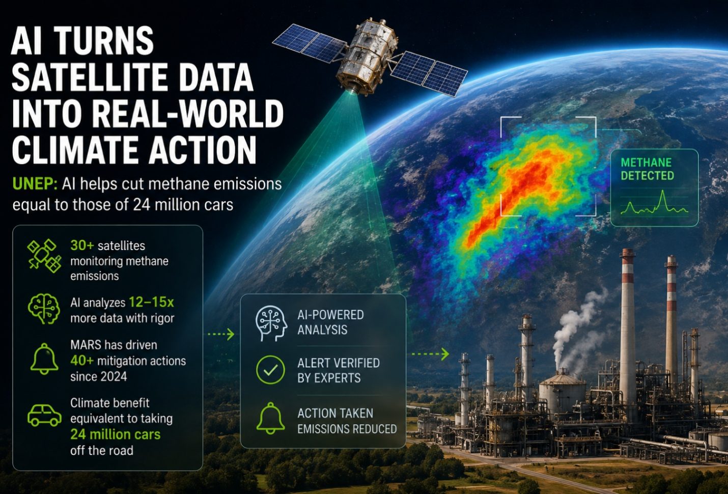
The operational centerpiece of satellite-based accountability is UNEP's Methane Alert and Response System (MARS), the first global system connecting satellite-detected methane emissions with a trackable notification process [5]. MARS integrates data from more than 30 satellite instruments and deploys AI models to distinguish genuine methane emissions -- such as leaks from oil and gas facilities -- from environmental noise [1][8]. The scale is telling: since 2023, the system has analyzed over 1.3 million satellite observations [1]. During its pilot phase from January to December 2023 alone, MARS detected more than 1,000 energy-sector methane plumes worldwide, linked 400 of them to specific facilities, and formally notified 127 events to six national governments and relevant OGMP 2.0 member companies [5]. The system is now expanding beyond oil and gas into the coal and waste sectors [1], and the UN Secretary-General has called on countries to respond to 80% of MARS alerts received -- a de facto responsiveness benchmark for the pledge era [1].
Crucially, the workflow keeps humans in the loop. Every AI-flagged detection is independently reviewed and verified by analysts at UNEP's International Methane Emissions Observatory (IMEO) before a notification is issued, ensuring decisions remain grounded in scientific judgment rather than algorithmic output alone [1]. "As new satellite missions increase the volume of methane data available worldwide, the challenge is no longer finding emissions but acting on them," UNEP's Krause observed. "UNEP's experience shows how AI can help bridge that gap, enabling faster identification of major methane releases and helping convert data into measurable emissions reductions" [1].
Deep Learning at the Detection Frontier
Behind these operational systems lies a fast-moving research frontier. Google researchers have developed deep learning approaches to map global methane emissions from space, aimed squarely at the point sources across waste, agriculture, and energy where mitigation pays off fastest [7]. Startups are pushing further. GeoLab, for instance, builds entirely new AI architectures tailored to satellite data, tackling what it describes as a key trade-off: the satellites with the best spatial coverage carry far poorer chemical information than specialized instruments. Its models -- trained on Google Cloud's Vertex AI infrastructure -- can tease out the methane signal from imperfect wide-coverage imagery, lowering detection thresholds by an order of magnitude compared with previous techniques [9]. That matters because most plumes are drowned in noise; without such methods, only very large leaks are visible at all [9].
Predicting Leaks Before They Happen
A complementary line of research aims to get ahead of emissions altogether. A University of Chicago Data Science Institute project led by Thomas Covert, Michael Greenstone, and Charlie Sheils pairs supervised machine learning with high-resolution satellite measurements to create a scalable inspection-targeting framework for regulators. The model trains on administrative data -- permitting records and historical inspections -- to predict which facilities are likely to leak, so that scarce satellite tasking and inspections can be aimed where risk is highest. A randomized controlled trial, run in close partnership with Colorado regulators, is designed to rigorously estimate the impact of this approach on regulatory enforcement and the benefits of improved monitoring [10]. If successful, it would mark a shift from reactive leak detection toward genuinely predictive regulation.
 High-Resolution Global Methane Mapping: Advances in Satellite Remote Sensing, Machine Learning, and Policy Frameworks
The Policy Layer: Converting Detections into Accountability
Regulation on Two Continents
Technology, by itself, enforces nothing. What gives satellite detections teeth is their embedding in law -- and here, movement is visible on both sides of the Atlantic. In the United States, the EPA's Super-Emitter Program formally incorporates third-party satellite observations into enforcement [2]. The European Union has gone further, requiring MRV of methane emissions across domestic oil, gas, and coal operations and, critically, across imports [3] -- a provision with global reach given that Europe is the world's largest LNG import market [5].
Market Leverage and Supply-Chain Transparency
Enforcement is not only regulatory. As gas consumers demand lower-emission products, a system is needed to quantify methane intensity across competing supply chains so that buyers can discriminate among suppliers and governments can levy fees [5]. UNEP's IMEO is building a Methane Supply Index for precisely this purpose, positioning itself as a neutral entity at the center of the methane data ecosystem to ensure its credibility and effectiveness [5]. In this emerging architecture, satellite data functions less like a police report and more like a credit score: a continuous, independently generated measure of methane performance that flows into procurement decisions, ESG disclosures, and, eventually, the price of a cargo of gas.
Persistent Headwinds on the Road to 2030
Detection Is Not Yet Enforcement
The most sobering lesson from the MARS experience is that data volume is outrunning institutional response. The Secretary-General's call for an 80% alert response rate is itself an implicit admission that many notifications currently go unanswered [1]. More broadly, the integration of satellite-derived methane data into national MRV systems, ESG disclosure frameworks, and sustainable finance remains inconsistent -- particularly in the Asia-Pacific region, where regulatory structures are complex and still evolving, and where initiatives such as the Centre for the Fourth Industrial Revolution are attempting to bridge the implementation gap [3].
Regulatory Whiplash and Geopolitical Asymmetry
The policy environment is also unstable. U.S. methane regulations have seen rollbacks under the Trump administration even as Europe and Asia tighten rules on imported fuels [6]. That asymmetry cuts both ways: exporters serving demanding markets face orbital scrutiny regardless of domestic policy, while emissions in jurisdictions with weak institutions may remain, for now, largely symbolic targets of satellite transparency. The one constant amid the policy churn, as industry observers note, is the enduring need for accurate methane monitoring itself [6].
Five Prerequisites for Closing the Gap
A recent comprehensive review distills what is required to convert technological capability into pledge compliance [2]:
- Continued expansion of high-resolution satellite constellations with sustained operational funding;
- Advancement of machine learning methods for automated detection and quantification;
- Integration of satellite observations with atmospheric inverse models for comprehensive flux estimation;
- Strengthening of regulatory frameworks that leverage satellite data for enforcement; and
- Investment in the capacity needed to act on what the data reveal.
The list is notable for what it implies: only two of the five prerequisites are purely technological. The remaining three are political and institutional -- a candid acknowledgment that the binding constraint has shifted from seeing methane to governing it.
 UNEP: AI helps cut methane emissions equal to those of 24 million cars - Csr Egypt | Csr Egypt
Conclusion: Transparency Is Necessary, Not Sufficient
Can satellite machine learning close the enforcement gap? The evidence suggests it can close a substantial part of it -- the part that has always been about information. The combination of dense satellite coverage, AI plume detection, and human analyst verification has made major methane releases visible within days rather than never, created trackable notification channels to governments and companies [5][1], and supplied regulators on two continents with evidentiary data streams that simply did not exist a decade ago [2]. The pathway to a 30% reduction by 2030 remains technically feasible and economically favorable, particularly in the fossil fuel sector where captured methane has commercial value [2].
But transparency is a necessary, not a sufficient, condition for enforcement. Atmospheric concentrations keep rising [3]; alerts go unanswered [1]; institutional uptake is uneven across regions [3]; and the political winds that determine whether satellite data carries regulatory force are fickle [6]. The decisive test will come in the second half of the decade, as Copernicus brings operational verification capacity online in 2027 [2], MARS extends into coal and waste [1], and the EU's import requirements begin to bite [3]. The past three years proved that algorithms can find the methane. The next five must prove that institutions can act on it. The satellites, in short, have largely done their part; the enforcement gap that remains is one of governance -- and it will be closed on the ground, or not at all.
References
- 1.
- 2.
- 3.
- 4.
- 5.
- 6.
- 7.
- 8.
- 9.
- 10.